June 23rd, 2009
 Here’s more positive bike news from south of the border.
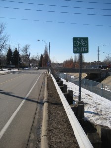
The Windsor Star is reporting a warm public response to a proposal to add bike lanes to Tecumseh Road in Tecumseh, Ontario, just outside of Windsor.
A $17-million project to eliminate the two-metre deep ditch along the west side of Manning Road and add bike lanes has residents mostly asking one question.
How soon can you do it?
The town sought public comment Monday on the options for reconstructing Manning from St. Gregory Street to Riverside Drive as part of the environmental assessment process.
Read the entire article
(via Bike Windsor)
Tags: bike lanes, Tecumseh, Windsor
Posted in On-road bicycling | No Comments »
June 23rd, 2009
 Google is soliciting input for new features in Google Maps.
We won’t tell you how to vote, but these features certainly would be welcomed.
- Add trail information to Terrain view
- Include walking and hiking trails in walking directions
- Add bike trail information and biking directions
If Google were to include this information on Google Maps, it could replace some current web sites designed to provide this information — especially those that require payment.
[Thanks to Sue Moretto for forwarding this information.]
Tags: Google Maps, Trails
Posted in Trails | No Comments »
June 22nd, 2009
 Last week the Great Lakes Metros Summit was held in Buffalo, New York.
And to quote Artvoice, this event was where “activists and policymakers from around the Great Lakes gathered to share homegrown solutions to Rust Belt problems.”
At the Summit, I moderated a panel on Complete Streets and Transit while also providing a brief overview status of Detroit’s greenways and non-motorized transportation based on my work for the Michigan Trails and Greenways Alliance (MTGA).
Our panel included Rory Neuner from the Michigan Environmetnal Council and a League of Michigan Bicyclists director. Rory is very active with the Walk and Bike Lansing campaign. They are working on a Complete Streets policy for Lansing.
If you are a Lansing resident, please visit their web site to learn how you can help make Lansing “accessible and walk & bike friendly!”
Next on the panel was Dom Nozzi of Richmond, Virginia. Dom has an invaluable web site devoted to making cities more bikeable and walkable. His four-part speech from Bloomington, Indiana really defines a vision for how we need to prioritize transportation for people first rather than cars.
After the summit, I had a chance to talk with Dom. One interesting point he made is that many people are stuck with outdated transportation paradigms, primarily that mobility — high speeds, wide roads — is the primary goal. They’ve committed themselves to this paradigm and cannot step back to view the bigger picture. They are often unconvinceable. An advocates best hope is they will be replaced or retire.
And also on the panel was Justin Booth, who certainly plays a major role in all the good things happening in Buffalo with respect to biking.
Justin created Buffalo’s Blue Bicycle program, a low-cost, simple, innovative means for sharing bikes across town.
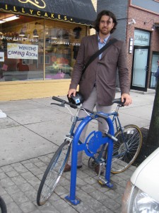
Also, Justin helped create the Rusty Chain beer program here a portion of sales from a custom locally-brewed beer go towards bike racks — an example of which is shown next to Justin in the above photo. To date the program has generated $10,000, which has been matched with city and federal funding (CMAQ). As a result, businesses within Buffalo’s Central Business District can request bicycle racks which are installed for free.
Buffalo recently installed 110 bicycle racks! Justin noted that the racks are custom designed and made locally.
That’s something worth raising a glass to.
Tags: bike parking, bike racks, bike sharing, Buffalo, complete streets, Dom Nozzi, Justin Booth, Lansing, MTGA, Rory Neuner, Rusty Chain Beer, Todd Scott
Posted in General bike news | No Comments »
June 20th, 2009

Make sure you stop by the M.T.G.A. booth at the RiverDays event this weekend on the RiverWalk
The Metro Times has a new article, Rolling on the Riverwalk, which provides an overview of Tri-Centennial state park construction and how it fits in with the Detroit RiverWalk.
In the current era of uncertainty in the auto industry, the Riverwalk is promising a bright future for human-powered movement.
And on a related note, today the Department of Natural Resources (DNR) is celebrating the 90th anniversary of Michigan State Parks. There will be a cake cutting at Tri-Centennial State Park at 4pm today, June 20th. So come downtown, enjoy the RiverWalk, Dequindre Cut, and have some cake.
The Detroit News has an article, Michigan ramps up roads and trails to make bicycling easier.
The Michigan Department of Transportation now maintains more than 2,560 miles of paved shoulder with bicycle access. The state also has more than 1,394 miles of rails-to-trails — abandoned railroad tracks that have been converted into biking, hiking and walking trails. Combine those rails-to-trails with trails through parks and public land, and downtowns and neighborhoods, and the stretch increases to more than 2,000 miles, said Nancy Krupiarz, executive director of the Lansing-based nonprofit Michigan Trails and Greenways Alliance. Additional bike-hike trails and greenways are expected.
This article wraps up with a great quote about biking from Rochester resident Colleen Brown.
“It’s like being a kid again. I always tell people that no matter how bad you feel, get on a bike. Ride around the neighborhood, feel the wind and sun on your face. You see the world differently. When you bike you can stop and smell the roses.”
Tags: Dequindre Cut, Detroit, Detroit Riverwalk, DNR, MDOT, MTGA, RiverDays, state parks, Tri-Centennial Park
Posted in Detroit, Trails | No Comments »
June 17th, 2009
The Center for Neighborhood Technology recently released a web tool that allows you to look at different geographic data relating to housing and transportation costs.
It’s called the H+T Affordability index. The thought is we shouldn’t look just at housing costs when evaluating house affordability. We need to consider transportation costs as well.
Often you’ll hear home buyers mention how much more house they can get further in the sprawling areas. What’s often not mentioned is living there has higher transportation costs because there’s more driving, less public transit, and reduced walkability and bikeability. Combining housing and transportation costs should give a more accurate estimation of affordability.
What’s interesting about the H+T web tool is it lets you select and view different datasets. One very interesting dataset is the average street block size. The smaller the blocksize, the most walkable the area likely is.
And more bikeable.
Below is a screenshot showing average block sizes for Metro Detroit. Based on my experience, this matches well with this area’s bikeability. Detroit and the inner ring suburbs are very good while the outer suburbs are not very good at all.

There are some dark spots in otherwise bikeable communities. These are often parks, golf courses, major industrial zones, or other superblocks.
Does this map estimate road bikability in your neighborhood?
Tags: housing affordability, sprawl
Posted in On-road bicycling | 1 Comment »